Hisn al-Sajra: the forgotten castle

Perched atop and in the center of la sierra mayor are the remains of a Moorish fortress. It’s name was Hisn al-Sajra, which is Zafra’s namesake. The fortress is deteriorating rapidly and will not be visible in fifty years, I’d guess; all that’s left are some half-buried foundations. I understand from reading “La Sierra del Castellar: La Historia Oculta de Zafra” by Jose Antonio Amador Redondo and Francisco Guzman Guzman that it was among a series of hill-forts built to protect the Guadiana valley (around Merida) from attacks by Cordoba and Sevilla during the early middle ages, when the Moors ruled this part of the Iberian peninsula. There is also some indication that the Moors built Hisn al-Sajra atop an earlier settlement (Roman?) but that, also, may have been built atop yet another settlement (ad infinitum) from the Bronze age. We have reason to believe that the top of the Castellar has drawn human attention for many thousands of years.

The top of the mountain is a mess of broken roof-tiles and pot sherds. I will detail some of the more impressive examples we’ve found in the “Artifacts” series of posts. On the surface it sounds irresponsible to remove anything from the various sites on the mountain, but the ground has suffered (and continues to suffer) hundreds of years of ploughing and livestock traffic. The ground is in places totally obscured beneath a carpet of goat and sheep droppings, and the cows haven’t been any less discreet. In a way, the overall poor quality of the site for archaeological examination and the manner in which the ground is constantly churned have helped us feel less guilty about our disruptive attempts to preserve some record of the fortress.

In the image above and the image below I’ve marked some points of interest. They are:

[1]la esquina (the corner) – This is the elbow in a little access road which permits us easy access to the mountainside. The fence-corner isn’t closed, so anyone (and any sheep) might simply slip through at will.

[2] guard tower – now I’m questioning the placement of this marker; it might be a tad further north. At any rate, this structure is totally gone save for a solid covering of roof tiles which have been stamped into the ground by animals. It’s elevated and would have given a view of both sides of the mountain as well as the neighboring ridge.

[3] entrance tower – today, this is the part of the fortress most visible from the Alconera side of the mountain (SW). It’s nearly buried in a mound of dirt and debris. The hard outside corner of the tower is still visible, bricks and mortar and all.

[4] mountain room – the only extant room of the castle. It faces the Zafra side (NE) and is accessible from that side at the cost of moderate physical toil. Very cool.

[5] northern guard tower – the castle’s northern termination point. I have found pieces of granite wheels on the mountainside beneath this tower, bespeaking its old utility as a mill or else a place for iron-sharpening.

Below is a north-justified Google Maps view. The castle walls are highlighted in yellow.

los caminos de los pinos y colorao – the paths “Colorao” and “of the Pines”

There are two notable hiking/bicycling paths along this part of the sierra. They are the camino de colorao and el camino de los pinos. I should disclaim that the signage available on-site is poor and so I’m not sure which is which. For me they blend together and their names are irrelevant, being modern and forgetful of their older, lost names.

[PURPLE/VIOLETA] el camino de colorao – Rouge Path – A truly lovely and long route around the southeast (less tall) section of the sierra. This path begins before you reach the dirt road which runs northwest/southeast on the northeast side of the ridge, at its foot. If you take the calle de carrotera, you will be turning left onto the path before you reach the aforesaid road. If you take calle de belen, you will be turning right onto the path before you cross the very old bridge (looks Roman). Taking the former direction will put you at la ermita de belen and from there you may climb its drive, step over the barrier to its picnic area opposite the chapel, and go up, up, and up until you come to the wide dirt path which circles around the back side (lado Alconera) of the ridge, depositing you at the hill-crest in sight of the major ridge. From there you may take the concrete road down and back to town. NOTE: this path is unkempt and probably won’t be passable in Spring (primavera) and even in the baked months, you must walk through a private olive orchard to connect the south leg with its northern companion.

[GREEN/VERDE] el camino de los pinos – Path of the Pines – As advertised, this path crosses beneath some grand Andalusian pines. You may access it from the concrete mountain road or from the choza (shepherd’s hut) at la ermita de belen. I prefer the latter starting point as it’s easier on my feet. My advice is to take the path up to the great old pine at the ridge-corner and follow it until it ends in a “T”, the left branch emptying onto the camino de colorao and the right leading you down the hill, past a ruined house and a watering hole and on north back to the concrete road.

on eastern access points

The sierra may be reached by many obvious (and less obvious) routes from Zafra.

Starting from the northern end:

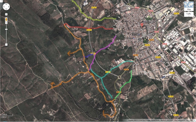
[YELLOW/AMARILLO] El Camino de los Naranjos – the Naranjos trail rolls and winds, is scenic and dumps you at the pantano, the dam. You may access the mountain from there but it is difficult.

[RED/ROJO] Buen Suceso – this path takes you down in front of the oldpalomar estate. The round building that looks as though its been transplanted from Alentejo is…a pigeon coop?

[PURPLE/VIOLETA] Calle de Carrotera – this road empties onto the bypass which circumnavigates the town. Simply follow it along to climb the most direct route up the mountain (that ugly grey cement road).

[BLUE/AZUL] Calle de Carrotera pt2 – a sneaky trick to get you tola esquina (the corner), as we call it, is to walk a couple dozen meters north on the bypass and turn left onto this path between fields. It will take you almost directly to the gap in the fence you’ll need to pass through in order to get up the mountain in a more scenic way than the road.

[TEAL/TURQUESA] camino entre campos – this is another path between fields that drops you onto thecamino de colorao, a lovely path which runs north-and-south, from the grey concrete road to Belen.

[GREEN/VERDE] Calle de Belen – not just a clever name. This one is the most direct route to take if you’d like to start your hike at the ermita de Belen.

[ORANGE/NARANJA] This road is an artery you’ll use no matter how you want to get up the mountain. The crude arrows I’ve drawn indicate ways in which you might subir (go up). The arrow farthest north protrudes from la esquina, or “the corner”; from here you hike up graze-land and probably through roving herds of sheep to get to the ridge. The arrow in the middle denotes the nasty scar of a road that runs up the main ridge’s southern end. It’s actually kind of tough on your feet so I recommend you choose any other way to subir (in spite of the added time). The southern orange arrow represents the camino de los pinos, which runs from Belen to the main ridge on the Alconera (the little village on the far side of the valley) side.